State Government of Maharashtra is planning to do geo-mapping and geo-referencing of urban properties

Image credits : DNA
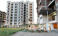
In Maharashtra, major land records reform is about to come as State Government of Maharashtra is set to do the geo-mapping and geo-referencing of urban properties and it will help the potential buyers and investors to keep themselves away from being cheated, reduce litigations and ease property transactions. Government will not map the properties on just papers of the property cards but also it will be in terms of geographical co-ordinates through which you can see the property with the help of Google maps. It will help the state governments to move to a clear and guaranteed title of land ownership in all over state.
The problem come in existence when government found that there is existence of multiple land registers such as; department of land registration, department of land records, municipal bodies and stamps whose data bases are not linked with each other. The land prices are shooting up in the sky and due to that most of the persons are trying to cheat the property buyers in transactions. However; the major drawback of the present system is that as a land owner all you need to provide the papers of land with presumptive title of the land without any guarantee of the ownership for that specific land. Whereas; the proposed new system will make the whole process easier for home buyers, small investors, large investors or industries by guaranteeing clear land title. With the help of new system it will be much easier to purchase a land without the help of experts or middleman because you will not need them to check the land records and land title as with the help of map you will be able to check flats or apartments title b yourself. According to Sambhajirao Kadu Patil, Settlement Commissioner and Director of Land Records, “This new system will reduce the cases in which land being sold to multiple parties. We will digitize and restructured all the property cards and they will be available on our website. We are doing mutations of land records, which will be available on our website, so if there will be any transaction at the sub-registrar’s office, it will be automatically recorded here”. The more he added that currently, there are 55 lakh property cards in all over Maharashtra.
According to Kadu Patil, “This is ultimate vision and concept to stop the cheaters by linking property records and municipal records in all the different departments. The more he added that currently we had a record of horizontal properties as well as records of vertical properties, which was constructed on them for the sales to other but they were not captured in those records, but these details are existed in the civic bodies for the purpose of assessment”. However; horizontal properties includes land and vertical properties include flats. Currently all the departments are working to bridge the gap and its big challenge, but we are working on that. The main concern is that whenever people purchase property or any other land, they just want to ensure the entry in the land records, but still there is no scientific geo-referencing of the site is available. And due to that now we are trying to capture the geographical co-ordinates of those properties such as; longitude and latitude on the property cards with an aim to tag them with universal co-ordinates, said one of the Senior Official from the department. The more he added that, We will examine and try to do this on the property cards because it will add the element of uniqueness in each and every property and property buyers or investors will be able to geo-reference as compared to the present system which is misleading enough to property buyers or investors.
According to officials, if property has not been measured properly, so its easy to sold them multiple parties or if plot has been sub-divided in different parts, so there is confusion on the sale and purchase. There will be no mapping of the individual plots or sub-divisions, until owner registered them because it can complicate the whole process. The geo-referencing of the property make it possible for individual apartments and flats to be mapped out with the details of transactions, sales and purchase.